Excavation and Ground Disturbance Permits for Plant Work

By shreen on February 23, 2026

excavation_ground_disturbance_permit_plant

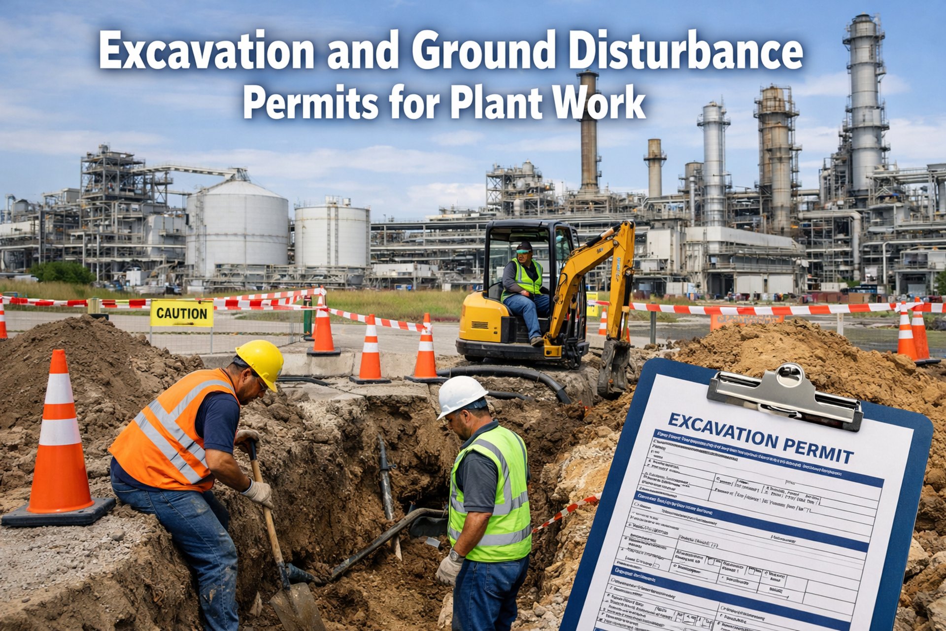
Every year, industrial plants report an average of 2,400 underground utility strikes during excavation work — each one a preventable incident that costs between $4,000 and $1.2 million depending on what gets hit. A ruptured gas line at a Gulf Coast refinery shut down operations for 11 days. A severed fiber-optic conduit at a pharmaceutical plant disabled batch control systems across three production buildings. A backhoe operator who cut through a live 480V electrical duct narrowly avoided electrocution because the circuit breaker tripped 0.3 seconds before lethal current reached the bucket. None of these incidents involved reckless operators — they involved permit systems that failed to communicate what was underground before digging began. Facilities that replace paper-based dig permits with digital permit management through Oxmaint reduce underground utility strikes by 89% and cut permit processing time from 3 days to 4 hours.

89%
Reduction in underground utility strikes when plants adopt digital excavation permit workflows with integrated utility mapping
3.2 hrs
Average permit approval time with digital workflows — down from 2.8 days with paper-based systems that require physical signatures and manual routing
$847K
Average annual cost of excavation-related incidents at mid-size industrial plants — including utility repairs, production downtime, and regulatory fines

Why Paper Permit Systems Fail Excavation Safety

Paper-based excavation permits were designed for an era when plants had a handful of underground utilities and one supervisor who knew where everything was buried. Modern industrial facilities have hundreds of subsurface assets — process piping, electrical conduits, instrument cable trays, fire water mains, sanitary sewers, storm drains, communication fiber, cathodic protection systems, and abandoned-in-place lines that still contain residual product. A paper permit cannot dynamically reference a GIS utility map. It cannot verify that the one-call ticket was completed. It cannot confirm that the excavation supervisor walked the dig zone with ground-penetrating radar results in hand. And when the permit sits in a supervisor's desk drawer waiting for a signature while the excavation crew stands idle at $2,800 per hour, the pressure to start digging before the permit is fully approved becomes irresistible. Schedule a demo to see how Oxmaint digitizes excavation permit workflows.


Incomplete Hazard Identification
Paper permits rely on the requestor knowing what utilities exist in the dig zone. When as-built drawings are outdated, abandoned lines are unmarked, or recent installations have not been added to facility maps, the permit approver has no mechanism to verify completeness — gaps in knowledge become gaps in protection.

Approval Bottlenecks
Excavation permits typically require signatures from operations, maintenance, safety, and sometimes environmental departments. A single unavailable approver delays the entire chain. Contractors waiting on permits bill standby time while production schedules slip — creating financial pressure to bypass or shortcut the approval process.

No Field Verification Trail
Paper systems cannot confirm that utility locates were actually performed, that hand-digging was used within tolerance zones, or that a competent person inspected the excavation before workers entered. The permit says these steps are required — but provides no evidence they were completed.

Expired Permits Left Active
Paper permits issued for a 48-hour window have no automatic expiration mechanism. Excavation crews working beyond the permitted timeframe or scope operate without current authorization — a compliance violation that increases incident risk and OSHA citation exposure.

Excavation Permit Requirements for Plant Work

Effective ground disturbance permits address five interconnected risk domains — each one a failure point where incomplete controls have caused utility strikes, cave-ins, environmental releases, or worker injuries. The Oxmaint permit management platform structures each domain as a mandatory workflow stage that cannot be bypassed or skipped, ensuring every excavation meets regulatory and facility-specific requirements before ground is broken.

Excavation Permit Control Center
UTL
Utility Identification and Mapping

Every excavation permit must document all known underground utilities within 15 feet of the planned dig zone. This includes active process lines, electrical conduits, communication cables, water mains, sewer laterals, and abandoned-in-place infrastructure that may still contain hazardous residues.

One-call ticket confirmation — verify state 811 notification completed and locate markings present before any mechanical excavation begins
Facility utility map review — compare current as-built drawings against field-marked locations and resolve discrepancies before digging
GPR or electromagnetic survey — conduct subsurface scanning where records are incomplete or abandoned lines may exist
Tolerance zone hand-dig protocol — document requirement for hand excavation within 24 inches of marked utility locations
Identifies unmarked or mislocated utilities before equipment contact
Catches abandoned lines containing residual hazardous materials
SOL
Soil and Ground Conditions Assessment

Ground stability determines excavation method, shoring requirements, and worker entry protocols. Soil classification under OSHA 29 CFR 1926 Subpart P directly dictates whether an excavation requires sloping, benching, shoring, or a trench shield — and the permit must document this determination before work begins.

Soil type classification — document Type A, B, or C soil determination based on visual and manual testing per OSHA Appendix A
Water table and drainage assessment — evaluate groundwater conditions and specify dewatering methods if excavation depth exceeds seasonal water table
Adjacent structure loading analysis — assess impact of excavation on foundations, roadways, and equipment pads within the zone of influence
Protective system specification — document sloping ratios, shoring design, or shield placement requirements for the classified soil conditions
Prevents cave-in fatalities caused by incorrect protective system selection
Identifies unstable soil from recent rain, vibration sources, or fill material
ENV
Environmental and Contamination Controls

Plant excavations frequently encounter contaminated soil, groundwater with dissolved hydrocarbons, or subsurface areas affected by historical spills. The environmental section of the excavation permit ensures proper sampling, containment, and disposal protocols are established before excavated material is removed from the dig zone.

Historical contamination review — check Phase I/II environmental records for the excavation area and identify known contamination plumes
Spoil management plan — specify stockpile locations, containment methods, and sampling requirements for excavated soil
Stormwater protection measures — install silt fencing, berms, or dewatering discharge treatment to prevent sediment or contaminated water from reaching storm drains
Prevents unpermitted discharge of contaminated groundwater
Catches soil contamination requiring special handling before disposal
ATM
Atmospheric Hazard Monitoring

Excavations deeper than 4 feet in industrial plant environments require atmospheric testing before worker entry and continuous monitoring during occupancy. Hydrocarbon vapors from contaminated soil, hydrogen sulfide from decaying organic material, and oxygen displacement from underground gas leaks create immediately dangerous conditions that surface-level observation cannot detect.

Pre-entry atmospheric testing — test for oxygen content (19.5–23.5%), LEL below 10%, and toxic gas concentrations below PEL before any worker enters the excavation
Continuous monitoring protocol — specify gas detector placement, alarm setpoints, and evacuation procedures for atmospheric changes during excavation work
Ventilation requirements — document forced-air ventilation specifications for excavations where atmospheric hazards are anticipated or detected
Detects oxygen-deficient atmospheres before workers enter excavation
Identifies explosive vapor concentrations from subsurface hydrocarbon sources
RST
Restoration and Backfill Verification

The excavation permit cycle does not end when the pipe is installed or the repair is completed. Improper backfill creates settlement that damages repaved surfaces, shifts pipe supports, and creates trip hazards. Incomplete restoration leaves open excavations that become fall hazards, water collection points, and regulatory violations.

Compaction testing documentation — record compaction density at specified lift intervals per engineering specifications
As-built drawing update — verify that new underground installations are recorded with accurate GPS coordinates and depth measurements in the facility utility database
Surface restoration sign-off — confirm pavement, concrete, landscaping, or ground cover restored to pre-excavation condition
Prevents future utility strikes by ensuring accurate as-built documentation
Catches inadequate compaction before surface settlement damages infrastructure
Every excavation permit should be a digital workflow — not a paper form in a desk drawer. Oxmaint structures utility identification, soil classification, environmental controls, atmospheric monitoring, and restoration verification into mandatory permit stages that cannot be bypassed.

Digital Excavation Permit Workflow: From Request to Closeout

The excavation permit lifecycle in Oxmaint follows a seven-stage workflow where each stage must be completed and verified before the next stage unlocks. This sequential gate structure prevents the most dangerous shortcuts — starting mechanical excavation before utility locates are confirmed, entering excavations before atmospheric testing is completed, or closing permits before as-built drawings are updated. Sign up to configure excavation permit workflows for your facility.

Step 1
Permit Request Submission
Requestor submits digital permit with excavation location (GPS-tagged), planned depth, duration, equipment type, and purpose. System auto-populates known utilities within 25 feet from facility GIS database.
Step 2
Utility Locate Verification
System requires upload of 811 one-call ticket confirmation and field locate photographs. For areas with incomplete records, GPR survey results must be attached before permit advances to approval routing.
Step 3
Multi-Department Approval
Permit routes simultaneously to operations, safety, environmental, and maintenance approvers. Each reviewer sees only their relevant sections. Parallel routing cuts approval time from sequential days to simultaneous hours.
Step 4
Pre-Dig Briefing and Field Verification
Excavation supervisor conducts toolbox talk covering utility locations, dig boundaries, protective system requirements, and emergency procedures. Digital sign-in captures attendance with timestamp and GPS confirmation at the dig site.
Step 5
Active Excavation Monitoring
Daily inspection checklists logged digitally — competent person verifies protective systems, atmospheric readings, utility clearances, and spoil pile setbacks. Photos of excavation conditions uploaded at each inspection interval.
Step 6
Backfill and Restoration
Compaction test results logged at each lift. As-built coordinates for new underground installations entered into facility GIS. Surface restoration photographs compared against pre-excavation baseline images.
Step 7
Permit Closeout and Audit Archive
Permit automatically closes when all restoration checkpoints are verified. Complete permit history — including every approval, inspection, photo, and test result — archived with permanent audit trail accessible for regulatory review.

Paper Permits vs. Digital Permit Management

The operational difference between paper-based and digital excavation permit systems shows up in every measurable dimension — processing speed, compliance completeness, incident rates, and audit performance. These comparisons reflect outcomes from industrial plants that have transitioned from paper to digital permit workflows.

Paper-Based Permits
Permit approval takes 2–4 business days with physical signature routing
No automated check for utility locate completion — relies on self-reporting
Expired permits remain in circulation with no automatic closure mechanism
Audit preparation requires 6–10 hours of manual record assembly per excavation
No photographic evidence trail for field conditions or protective systems
Permit forms stored in filing cabinets with 15–25% loss or misfiling rate
Oxmaint Digital Permits
Parallel approval routing completes permits in 2–6 hours with mobile signatures
Utility locate verification is a mandatory gate — permit cannot advance without uploaded confirmation
Permits auto-expire at scheduled end time with notification to all stakeholders
Complete audit package generated in under 3 minutes per excavation — one click export
Time-stamped, GPS-tagged photos required at each inspection checkpoint
Cloud-archived with searchable permit history across all facility excavations

How Oxmaint Manages Excavation Permit Compliance

Oxmaint structures excavation permit management around four integrated capabilities — each one addressing a specific gap in paper-based permit systems that contributes to utility strikes, compliance violations, and audit failures. Book a demo to see these capabilities configured for your facility.


Sequential Gate Workflow Engine
Each permit stage acts as a locked gate — utility locates must be verified before approval routing begins, atmospheric testing must be logged before worker entry is authorized, and compaction records must be uploaded before permit closeout. No stage can be skipped regardless of schedule pressure or supervisory override.
Workflow Automation Compliance Gates

GIS Utility Map Integration
When a permit request is submitted with GPS-tagged dig coordinates, Oxmaint auto-queries the facility utility database and populates the permit with all known underground assets within the buffer zone. Approvers review actual utility data instead of relying on the requestor's memory of what might be underground.
Asset Mapping Auto-Population

Mobile Field Inspection Logging
Competent persons log daily excavation inspections from mobile devices — atmospheric readings, protective system condition, spoil setbacks, and water accumulation documented with timestamped photographs and GPS verification that the inspector was physically present at the excavation site.
Mobile Inspections Photo Evidence

Automatic Expiration and Escalation
Permits auto-expire at scheduled end time with 4-hour advance warnings sent to the excavation supervisor and permit holder. Extension requests require re-verification of soil conditions and protective systems before renewal is granted — preventing indefinite open excavations that degrade protective measures over time.
Auto-Expiration Escalation Alerts
We had a contractor sever a 6-inch process cooling line because the utility map he was given was from 2014 and the line was relocated in 2017. Three years of paper permits and nobody updated the drawing. After we moved to digital permits with auto-populated utility maps, every new installation gets GPS-tagged at closeout and appears on the next permit request automatically. We have not had an underground strike in 22 months.
Plant Maintenance Director — Petrochemical Facility, Texas

Digitize Your Excavation Permit Program

Oxmaint replaces paper-based excavation permits with structured digital workflows — integrating utility mapping, multi-department approvals, field inspection logging, automatic expiration, and complete audit archiving into a single platform that prevents the shortcuts and information gaps that cause underground utility strikes and compliance violations.

Frequently Asked Questions

Q What depth triggers the need for an excavation permit at an industrial plant?
Most industrial facilities require excavation permits for any ground disturbance — even surface scraping — because underground utilities at industrial plants can be buried as shallow as 6 inches. OSHA requirements for protective systems begin at 5 feet of depth, but the utility strike risk exists at any depth where subsurface infrastructure is present. Best practice is requiring permits for all mechanical ground disturbance regardless of depth, and Oxmaint configures permit triggers based on your facility's specific depth and location criteria.
Q How does digital permit management integrate with existing plant safety systems?
Oxmaint integrates with existing plant safety management platforms through API connections that synchronize permit status with hot work permit systems, confined space entry permits, and lockout/tagout programs. When an excavation occurs near an active process line, the system can automatically generate associated LOTO work orders and notify operations of the proximity — ensuring that all related safety controls are coordinated through a single digital workflow rather than managed independently on separate paper forms.
Q What happens when excavation conditions change after the permit is approved?
When field conditions differ from permit assumptions — such as encountering unexpected soil types, uncharted utilities, or groundwater — the digital permit enters a hold state that requires re-evaluation by the competent person and safety department before work resumes. Updated soil classifications, revised protective system specifications, and new atmospheric monitoring requirements are documented within the permit record, maintaining a complete change history that demonstrates compliance with the duty to reassess conditions throughout the excavation lifecycle.
Q How long should excavation permit records be retained?
OSHA does not specify a minimum retention period for excavation permits specifically, but environmental regulations (RCRA, CERCLA) and state requirements often mandate 30-year retention for records related to subsurface work at industrial facilities. Schedule a demo to see how Oxmaint archives permit records with permanent cloud storage, full-text search, and export capabilities that satisfy the most stringent retention requirements without the physical storage burden of paper filing systems.
Q Can Oxmaint handle emergency excavation permits for urgent repairs?
Yes. Oxmaint includes an expedited permit workflow for emergency ground disturbance — such as repairing a ruptured underground water main or addressing a subsurface gas leak. The emergency pathway compresses the approval chain to a single authorized approver, but still requires utility locate confirmation and atmospheric testing before mechanical excavation begins. Emergency permits auto-escalate to full post-incident review within 48 hours to capture lessons learned and update facility utility maps with any newly discovered subsurface conditions.

Share This Story, Choose Your Platform!