Weather-related crashes cost the US trucking industry $2.4 billion annually in vehicle damage, cargo loss, and liability settlements. The Federal Highway Administration documents that 21% of all vehicle crashes are weather-related — 1.2 million crashes per year — with commercial fleets disproportionately represented because they operate in conditions that passenger vehicles avoid. The core problem is not that fleet managers do not know bad weather is coming. They do. The problem is that standard route planning tools treat weather as a post-hoc adjustment — the dispatcher calls the driver after the storm hits, not before the route is committed. Weather-aware fleet routing integrates real-time meteorological data directly into the dispatch decision, rerouting vehicles around developing hazards 2–6 hours before conditions deteriorate to dangerous levels. Fleets running weather-integrated routing report 31% fewer weather-related incidents, 18% lower fuel consumption from avoiding stop-and-go weather traffic, and measurably better on-time delivery rates despite the longer routes that weather avoidance sometimes requires. If your fleet dispatch still relies on drivers calling in road conditions rather than AI predicting them, start a free trial with Oxmaint or book a demo to see weather-aware routing in action.
Fleet Safety · Weather Routing · AI Dispatch
Weather-Aware Fleet Routing: How AI Keeps Your Vehicles Moving Safely When Conditions Turn Against You
Real-time weather integration in fleet routing is not a navigation feature — it is a risk management system. Storms, ice, flooding, and high winds are predictable hazards. AI-driven weather-aware routing predicts them, models their impact on every active route, and reroutes vehicles before conditions become dangerous — not after.
$2.4B
Annual weather-related fleet crash cost — US trucking industry alone
31%
Fewer weather-related incidents with AI-integrated routing vs. manual dispatch
21%
Of all US vehicle crashes are weather-related — FHWA annual benchmark
The Dispatch Gap
Why Standard Fleet Routing Fails in Weather Events
Weather-related fleet incidents are rarely caused by unexpected conditions. They are caused by known conditions that reached drivers too late to change decisions already made hours earlier. Four dispatch failure modes explain why standard routing leaves fleets exposed.
01
Route Committed Before Weather Develops
A driver leaves the depot at 6 AM on a 340-mile run. By 11 AM, a winter storm warning is issued for the mountain corridor on his route. The dispatch system has no mechanism to detect the conflict between his committed route and the developing weather event. The driver calls in when conditions deteriorate — 5 hours after the route decision was locked.
Result: Driver exposed to preventable hazard. Reactive decision made under time pressure at roadside.
02
Weather Alerts Delivered to Dispatchers, Not Routes
A dispatcher receives a National Weather Service flash flood watch for a county. She has 12 vehicles on active routes. She has no automated way to identify which of those 12 routes passes through the watch area, at what time, and whether rerouting is still possible. She manually checks each route — a 45-minute process while conditions are actively worsening.
Result: 3 of 12 vehicles already past the rerouting decision point before analysis completes.
03
No Cargo-Sensitivity in Weather Decisions
A 40 mph crosswind advisory affects a highway corridor. A standard routing system either ignores it or applies the same reroute logic to all vehicles. A weather-aware system applies cargo-specific thresholds — a flatbed carrying wind-sensitive oversized loads is rerouted at 35 mph crosswinds while a standard van holds the route to 50 mph. Cargo type changes the safe wind limit by 15–30%.
Result: Uniform weather rules create both over-restriction and under-protection depending on vehicle configuration.
04
No Post-Event Analysis to Improve Future Routing
A fleet experiences three weather-related delays in one winter season — all on the same I-76 mountain corridor between November and March. No system captures this as a learnable pattern. Next season's routing uses the same corridor without any seasonal weather-risk weighting. The same delays repeat because the routing intelligence has no memory.
Result: Seasonal weather patterns repeat as operational surprises instead of planned variables.
Hazard Types
The Six Weather Hazards That AI Routing Addresses — and How Each Is Handled
Weather-aware routing is not a single algorithm — it is a set of hazard-specific models, each calibrated to the physics of how that hazard affects vehicle safety and transit time. Understanding how each hazard type is processed reveals why AI routing outperforms human dispatcher judgment on time-compressed weather decisions.
AI integrates road surface temperature forecasts (not air temperature — which lags surface by 2–4°C) with precipitation probability. Black ice forms on bridges and overpasses first — hazard maps weight elevated roadway segments at 2.5x standard icing risk.
Routing action: Avoids elevated corridors and known shaded segments. Extends vehicle following distances in driving behavior recommendations. Adjusts ETA by 22–35% on affected segments.
Ice-related crashes cause $1.1B in commercial vehicle damage annually — highest single weather hazard cost
Snow intensity forecasts at 15-minute intervals combined with road treatment status data (states publish salt truck deployment via API in 34 US states). AI distinguishes between treated major highways (manageable) and untreated secondary routes (avoid).
Routing action: Shifts to treated major arterials even when longer. Issues hold recommendations when snowfall exceeds 2 inches/hour. Provides shelter waypoint options with open truck stops and rest areas mapped on alternate routes.
Heavy snow reduces commercial vehicle average speed by 38% and increases fuel consumption by 24% on unoptimized routes
Flood hazard models use topographic elevation data combined with real-time precipitation to predict water accumulation on route segments 2–4 hours ahead. Underpasses, low-gradient corridors, and bridge approaches are flagged as primary flood-risk waypoints.
Routing action: Avoids flood-risk segments proactively. Integrates USGS stream gauge real-time data for known flood-prone crossings. Issues immediate reroute if active flood closure reported by DOT or driver crowdsource.
A standard commercial truck becomes uncontrollable in as little as 12 inches of moving water — flash flood decisions must be made hours early, not at the crossing
Wind hazard scoring accounts for vehicle height and cargo configuration (empty trailers are 40% more vulnerable than loaded), route exposure (open plains vs. sheltered valley corridors), and gust frequency. High-sided vehicles on known wind corridors — Cajon Pass, Wyoming I-80, eastern Oregon — receive cargo-specific thresholds.
Routing action: Recommends sheltered alternate routes for high-sided loads. Issues parking holds at available facilities when gusts exceed vehicle-specific safe limits. Adjusts speed recommendations on exposed segments.
Wind rollovers cost commercial fleets $420M annually — 80% occur on known high-wind corridors that weather-aware routing can avoid
Fog formation models use temperature-dewpoint spread, terrain shelter analysis, and historical fog frequency data to predict dense fog 1–3 hours before it reaches NWS advisory threshold. Valley fog is predictable by 11 PM based on conditions — AI routes morning departures away from known fog corridors before drivers depart.
Routing action: Delays departure recommendations to allow fog to clear on affected segments. Identifies alternate elevated routes that typically clear earlier. Flags multi-vehicle pileup risk corridors with historical incident data.
70% of fog-related commercial vehicle crashes occur on corridors with documented fog frequency — predictable and avoidable with historical route intelligence
Extreme heat affects tire pressure (1 PSI increase per 10°F — critical for vehicles near maximum load), pavement blowouts at road surface temperatures above 140°F, and driver fatigue acceleration. Heat routing models integrate vehicle maintenance records — vehicles with aging tires receive lower heat thresholds for routing restrictions.
Routing action: Recommends cooler time-of-day departure windows. Flags vehicles with maintenance records showing tire age above 4 years for heat-day tire check before dispatch. Identifies rest stop waypoints with shade and cooling facilities on long summer runs.
Tire-related breakdowns increase 34% during heat waves — 68% of these are preventable with pre-dispatch tire pressure checks triggered by heat routing alerts
Weather Intelligence in Oxmaint Fleet
Real-Time Weather Integration That Moves With Your Vehicles — Not Just Your Depot
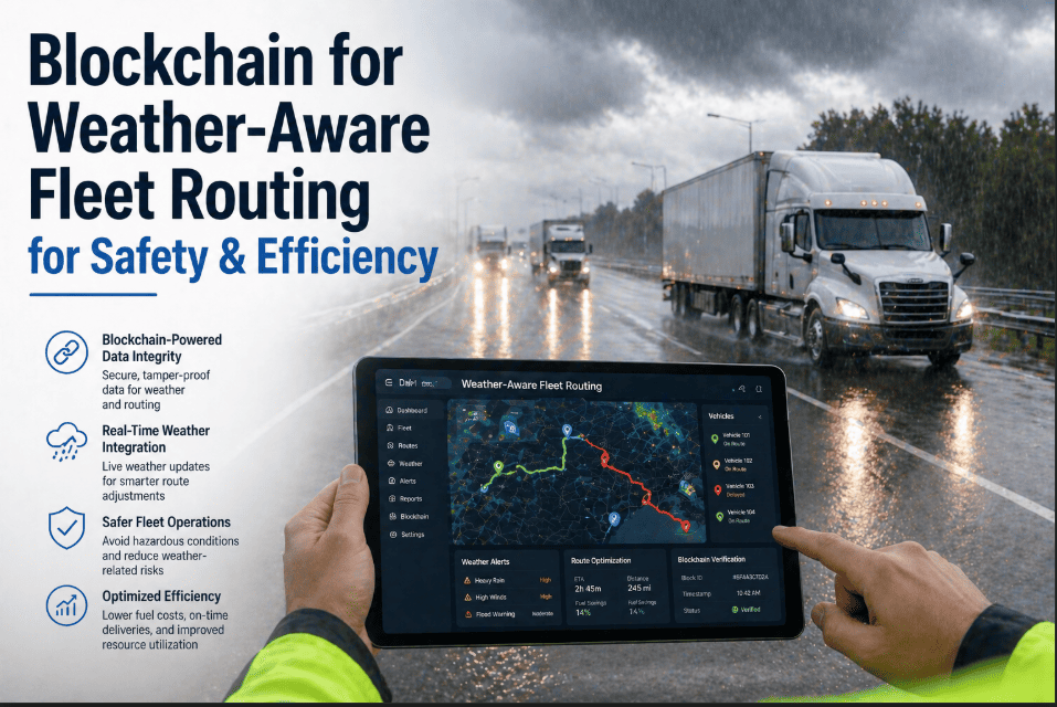
Oxmaint's weather-aware routing monitors every active vehicle's projected route against live weather data — not just departure conditions. Weather develops while vehicles are en route. Your routing intelligence needs to develop with it.
Platform Capabilities
How Oxmaint Delivers Weather-Aware Fleet Routing
Live Data
Real-Time Weather API Integration
Integrates NOAA, Weather.com, Tomorrow.io, and DOT road condition APIs simultaneously. Weather data refreshed every 15 minutes for active routes. Covers precipitation, temperature, wind speed, visibility, road surface conditions, and NWS advisory status in a single unified feed.
Weather data granularity: 1km grid resolution, 15-minute refresh interval
Predictive
6-Hour Forward Route Weather Modeling
AI models weather conditions at each route waypoint 6 hours forward — not just current conditions at the vehicle's current location. A vehicle 120 miles from a developing ice storm needs rerouting intelligence now, not when it arrives at the hazard.
Hazard identification 2–6 hours before vehicle reaches affected segment
Vehicle-Specific
Cargo and Configuration Thresholds
Weather thresholds calibrated by vehicle type (flatbed vs. enclosed trailer vs. tanker), cargo sensitivity (hazmat, refrigerated, oversized loads), and vehicle maintenance record (tire age, brake system condition). One weather event generates different routing recommendations for different vehicle configurations.
Vehicle-specific risk thresholds prevent both over-restriction and under-protection
Auto-Reroute
Automated Rerouting With Driver Notification
When weather triggers a rerouting threshold, Oxmaint automatically calculates the optimal alternate route, presents it to dispatcher for one-click approval, and pushes the updated route to the driver's mobile app simultaneously. Approval-to-driver notification in under 60 seconds.
Rerouting decision and driver notification within 60 seconds of threshold trigger
Learning
Seasonal Pattern Intelligence
Historical weather incident data combined with route performance records builds seasonal risk profiles for specific corridors. I-80 Wyoming in February, I-5 California in December, Florida coastal routes in hurricane season — each receives historically-calibrated risk weighting that improves routing intelligence year over year.
Seasonal weather patterns become routing intelligence, not operational surprises
Compliance
Weather Hold and Driver HOS Documentation
When weather conditions require a vehicle hold, Oxmaint documents the weather condition trigger, the hold decision, and the driver's hours-of-service status. Weather holds that affect HOS compliance are flagged for dispatcher and driver record. Documentation supports insurance claims and regulatory review following weather incidents.
Weather decision audit trail for compliance and insurance documentation
Live Decision Flow
How Weather-Aware Routing Works in Real Time — The Decision Sequence
T-6hr
Pre-Departure Weather Briefing
6 hours before scheduled departure, Oxmaint runs full route weather analysis for the planned transit window. Weather risk score generated per route segment. High-risk segments flagged to dispatcher before driver assignment confirmed.
T-2hr
Departure Decision Analysis
Final pre-departure weather check with updated forecast data. If conditions have deteriorated since T-6hr analysis, dispatcher receives departure delay recommendation with alternative departure window that avoids projected hazard peak. Driver receives weather briefing on mobile app.
En Route
Continuous Route Monitoring
Every 15 minutes, AI re-evaluates the remaining route against current weather data. Vehicle position tracked against developing conditions. If weather worsens on route ahead, rerouting calculation runs automatically and presents alternate route to dispatcher for review.
Alert
Threshold Breach — Reroute Triggered
Weather condition at a forward route segment exceeds vehicle-specific threshold. System calculates three alternate routes with weather scores, ETA impact, and fuel cost delta. Dispatcher receives one-click approval interface. Approved route pushes to driver mobile in under 60 seconds.
Hold
Safe Haven Recommendation
If no safe alternate route exists and conditions exceed all route options, system recommends nearest approved shelter facility — truck stop, rest area, or customer site — with capacity verification, amenities, and estimated weather-clear time for departure planning.
Post
Incident Learning and Route Scoring Update
Every weather-affected transit is logged with actual conditions encountered vs. forecast, actual delay vs. model prediction, and driver observation notes. Data updates the AI model — improving forecast accuracy and threshold calibration for future routes on the same corridor.
Capability Comparison
Standard Fleet Routing vs. Weather-Aware AI Routing
| Capability | Standard Routing | Oxmaint Weather-Aware Routing |
| Weather data integration | None or driver-reported | Real-time NOAA, DOT, and commercial weather APIs |
| Hazard detection timing | At or after hazard encounter | 2–6 hours before vehicle reaches affected segment |
| Rerouting trigger | Driver calls dispatcher | Automated threshold detection with one-click approval |
| Vehicle-specific thresholds | Same rule for all vehicles | Cargo type, height, weight, and maintenance history |
| Seasonal pattern learning | None — same route each year | Historical corridor risk profiles updated annually |
| Safe haven identification | Driver finds their own | AI-identified with capacity verification and amenities |
| Compliance documentation | Manual incident report | Automated weather-decision audit trail |
| Post-event learning | None systematic | Every event updates the routing model |
Measured Outcomes
What Fleets Report After Implementing Weather-Aware Routing
31%
Fewer Weather-Related Incidents
Proactive rerouting before hazard encounter eliminates the majority of weather-related crashes, rollovers, and road departures that reactive routing cannot prevent
18%
Lower Fuel Cost on Weather Days
Avoiding weather-affected corridors eliminates stop-and-go congestion from crashes ahead and reduces idle time from holds — net fuel savings despite sometimes-longer alternate routes
24%
Improvement in On-Time Delivery
Proactive rerouting maintains transit velocity. Reactive routing — waiting until conditions deteriorate — creates delays of 2–6 hours that proactive alternatives would have avoided entirely
$180K
Average Annual Incident Cost Avoided
Per 50-vehicle fleet — combining vehicle damage reduction, insurance premium impact, cargo loss prevention, and liability settlement avoidance from weather-related incidents prevented
Common Questions
Weather-Aware Routing — Questions Answered
Does weather-aware routing work internationally or only in the US?+
Oxmaint's weather routing integrates global weather data providers — Tomorrow.io, Weather.com, and regional meteorological services — covering North America, Europe, Australia, and the UAE with real-time resolution. Road condition data (salt treatment status, DOT closures) is strongest in the US and Canada where state and provincial DOT APIs are most developed. European fleets benefit from Copernicus Climate Change Service data and national road authority integrations. Coverage quality is highest in regions with well-developed DOT data infrastructure, but weather hazard prediction itself is globally available.
Book a demo to discuss coverage in your operating region.
How does the system handle situations where all alternate routes also have weather hazards?+
When all available routes exceed safe thresholds — a regional storm event that covers a broad area — the system shifts from rerouting recommendations to hold recommendations. It identifies the nearest approved safe haven facility, provides the dispatcher with estimated weather-clear timing based on storm movement models, and generates a revised delivery ETA based on the hold duration. In these situations, the value of the system is not rerouting — it is the early identification that a hold decision is necessary, made 2–4 hours before the driver would have encountered conditions that forced an unplanned stop on the roadside rather than at a facility.
Can weather routing recommendations be overridden by dispatchers or drivers?+
Yes — and this is by design. Oxmaint's weather routing provides recommendations and one-click approval workflows, not autonomous route changes. Dispatchers always have override authority. Driver override of weather recommendations requires dispatcher confirmation — a two-step process that ensures the override decision is documented and deliberate rather than impulsive. Override decisions are logged with the weather condition at the time of override, the overriding party, and the subsequent actual conditions encountered. This creates the audit trail that matters for insurance and regulatory purposes when overrides are made.
How does weather routing integrate with our existing fleet management and TMS systems?+
Oxmaint integrates via REST API with major TMS platforms including McLeod, MercuryGate, Oracle TMS, and SAP TM. Existing route plans import directly from the TMS, weather analysis runs against those routes, and approved reroutes are pushed back to the TMS and to driver ELD/mobile simultaneously. For fleets using proprietary dispatch systems, webhook-based integration passes weather alerts and route recommendations as structured data that existing systems can consume without full platform migration.
Start a free trial to test integration with your current systems.
Protect Your Fleet From Weather
Weather Is Predictable. Weather-Related Fleet Incidents Should Be Preventable. Oxmaint Makes Them Both.
Every storm, ice event, flood warning, and high-wind advisory that affects your routes is detectable hours before your vehicles reach it. Oxmaint's weather-aware routing detects it, models its impact on every active route, and delivers a rerouting recommendation in time to act — not in time to report the incident afterward.